Hi Meg,
Here’s a blog post that I hope will help clarify the answer to this common question.
Blog Post Link:
http://blogs.esri.com/esri/arcgis/2013/02/19/about-features-and-feature-services/
Blog Post excerpt:
Importing data into your map
You can add a .csv or .txt file with lat/long coordinates or addresses, or any shapefile, by clicking Add, then
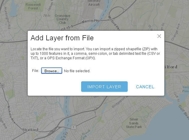
choosing Add Layer from File. Shapefiles are a collection of individual files, and they must be zipped and must include the projection file (.prj).
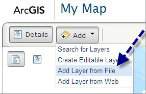
Depending on your browser, you can also drag-and-drop .csv and .txt files onto your map.
When adding data in this way the features in the source are imported and used to create a feature layer that
is stored and managed in your web map. Because the storage and management of imported features must be handled in the context of the web map and browser, there is an inherent limitation to how many features can be efficiently managed. ArcGIS Online sets an
outside limit of 1,000 features from a shapefile, or 1,000 features from a .csv, or .txt file using lat/long coordinates (the limit is 250 features using addresses).
---
So, if you want to create a web service of any size which is hosted in your ArcGIS Online organizational account and then share it with others via an ArcGIS Online web map, I encourage you to use the “publish
features from ArcMap documents” or “publish features from ArcGIS Pro maps” approach. This approach imposes no limit on the number of features. But keep in mind that the web map (and more importantly the browser) will have a “limit” to the amount of data it
can render and still perform well. So to ensure your web map users have a good performance experience, we would recommend enabling scale-dependent rendering on layers with a large number of features.
Publish Features from ArcMap Documents:
Publish Features from ArcGIS Pro Maps:
Hope this helps! Please let me know if you have any other questions.
Thanks,
-Josh
Joshua Williams |
Account Manager
Esri
| 35 Village Road Suite 501 | Middleton, MA 01949 | USA
T 978-777-4543 Ext. 1-8425| F 978-777-8476
From: Unmoderated discussion list for Connecticut GIS Users [mailto:[log in to unmask]]
On Behalf Of Meghan McGaffin
Sent: Friday, December 19, 2014 12:50 PM
To: [log in to unmask]
Subject: [CTGIS-L] more than 1,000 features ArcGIS Online
Am I missing something? I thought with an organizational account it was possible to load shapefiles with more than 1,000 features?
Meg McGaffin
GIS Analyst
City of Milford CT
70 West River St
Milford, CT 06460
203-783-3393
------------------------------------------------------------------------- This list (CTGIS-L) is an unmoderated discussion list for all CT GIS Users.
If you no longer wish to receive e-mail from this list, you can remove yourself by going to
http://listserv.uconn.edu/ctgis-l.html