Go Find a Benchmark!
April is Global Citizen Science Month. We invite you to celebrate with NGS by GPS’ing a benchmark, submitting a
mark recovery, and sharing your OPUS solution. While GPSonBM is more crowd-sourcing than citizen science, it does make that direct connection between citizens and science. We are proud to announce that our program is now listed on
CitizenScience.gov!
In the past, when NGS was part of the U.S. Coast and Geodetic Survey, we had what we affectionately call the “roving bands of surveyors” who literally walked across the country, East to West, North to South, moving their families in caravans along the survey
routes. The vast amounts of data they collected was used to create the geodetic datums we use today, NAVD 88 and NAD 83. Today, we are modernizing the National Spatial Reference System, but we don’t have the roving bands of surveyors anymore. Luckily, GPS
technology has become so accurate, accessible, and affordable, and the Internet has made data sharing so easy, that we can now rely on a crowd-sourced data collection model to enable you to improve the local accuracy of NGS models and tools in the areas where
you use them most.
Remember - get your data in by the December 31st, 2021 cut-off date to ensure your data is used to improve the transformation tools.
|
Recent Progress
In the March GPSonBM update, we reminded you that this is the last full field season to collect and submit data to be used in the initial release of the modernized National Spatial Reference System. We also challenged you to beat the data submission
record set back in 2018 at the height of the GEOID18 data collection campaign. The submissions have been counted, and YOU DID IT! A record breaking 1,649 OPUS solutions were shared in March 2021. This surge, on top of the strong increasing trend over the past
year, bodes well for the GPSonBM Transformation Tool Campaign. It also shows that NGS’ crowd-sourcing approach can be mutually beneficial and unleash the full potential of the modernized NSRS.
|
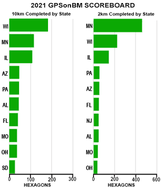
Partner Highlight: Puerto Rico

This month, we congratulate our friends in Puerto Rico on their great strides in collecting and sharing GPSonBM data across the islands. Enthusiasm runs high, and collaboration is strong among the relatively small geospatial community in Puerto Rico. Collectively,
they have completed over 75% of the 10-km hexagons that NGS has requested for the NAPGD 2022 Transformation Tool. In addition, they have started building a time series of repeat GPS observations to better understand the impacts of last year’s magnitude 6.4
earthquake and other land motion on the island’s survey control network. These repeat observations are preparing Puerto Rico to take full advantage of the Modernized NSRS’s new time dependent functionality. NGS offers a sincere "Muchisimas Gracias" to all
of those working together toward the common good (especially those whose names rhyme with vector).
|
Call to Action: Listen, Observe & Submit

In case you missed it, there’s still time to check out the
Surveyor’s Week edition of the NSPS Surveyor Says! podcast featuring a discussion of GPSonBM and other great stuff NGS has been up to. So this month, as you prepare to submit your GPSonBM data to NGS, tune in and listen while your GPS receivers cook over
some priority points!
|
NGS tracks participation in this campaign, but we rely on partner participation to be successful. If you have an accomplishment you want to highlight, email
[log in to unmask].
|